|
|
|
The Geomorphology of the River Aire Valley
Location
The River Aire proper rises at the foot of Malham Cove, (OS 389800, 464200) about 300m above sea level and flows about 141 km generally southeast, becoming tidal at Chapel Haddlesey. It joins the River Ouse some 16 Km downstream at Airmyn (472300,426200), giving it a point to point distance of about 91 km flowing in a general direction of 115°. Leeds is half way down and the river here is typically 30m above sea level. Including it's major tributary, the Calder, it has a catchment area of about 225,000 hectares, though for the purpose of this exercise we will regard the Aire Valley as that area of some 125,000 hectares, excluding the Calder.
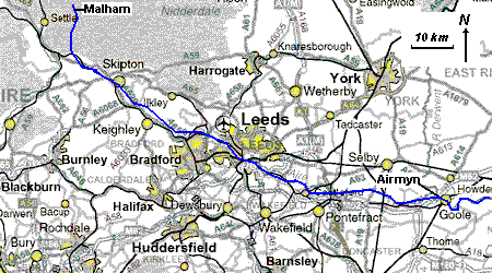
Fig. 1 The course of the river Aire
Geology.
For it's short distance the Aire Valley has a striking, varied and initially, complex geomorphology. Especially remarkable is the fact that the river, in it's initial development might be assumed to emanate from Malham Tarn, but because of the subterranean path it takes after this lake, it's nascence is not so straight forward.
We can see from Fig. 2 that the stream which leaves the Tarn to disappear at "A" emerges somewhat downstream of the cove at Airehead springs. The waters which emanate from the cove in fact sink somewhat west of the Tarn, around B. The streams cross on their underground journey! (As we can see from Fig 2, Gordale Beck, by virtue of it's length has a claim to be the source of the Aire).
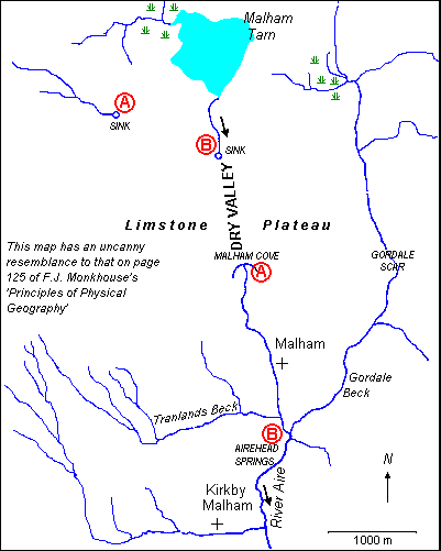
Fig. 2 Hydrology of the upper Aire
One may imagine the Pennines to form a somewhat eroded anticline, crossed by major faults. The upper reaches are dominated by Carboniferous measures, yet in places, the more ancient, Silurian, rocks are evident (e.g. at the foot of Gordale Scar). As the river progresses eastward the surrounding rocks become younger, and we see a progression through Magnesian Limestone about Knottingley, Permian Red and New red sandstone then more recent depositions of Warps, Peats and Sands.
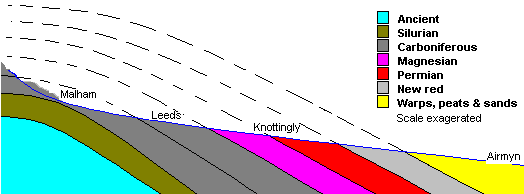
Fig. 3 West - East cross section of the River Aire, showing basic strata order
Evidence of maturity is naturally more marked downstream, but meandering and deposition are quite marked below Leeds, eventually the geology of the banks being dictated by the river, with muds, sands and clays comprising the lower reaches.
Within the Strata, especially the carboniferous, is a wealth of sub-strata, which apart from giving rise to a fascinating geology are the basis for the development of West Yorkshire (but that's another story). The most notable measures are the Limestone (giving a very typical karst topography to the Yorkshire Dales), The hard grits, giving the hills their whale backed shapes by creating resilient summits, and the coal measures.
Topography
The entire Aire Valley has been glaciated, and we see evidence of this in Boulder Clays, moraines, erratics, striations and dry valleys (e.g. above Malham cove).
The upper reaches are, like the river's neighbours to the north and south, in a deep trough like valley, (Airedale), where the erosional aspects of glaciation are most obvious. The dominant features of the lower valley, which is very much broader and more gentle-sloping, are essentially man made; though pockets of natural landscape still survive (e.g. at Swillington Park). The low-lying nature of the lower valley has been bought sharply into focus by the floods during 2001, when a large body of water inundated the area.
References
Gray, Johnnie, Through Airedale from Goole to Malham, Old Hall Press, 1990
Monkhouse, Fred, Principles of Physical Geography, Hodder and Stoughton, 1985
http://www.britannica.com/bcom/eb/article/7/0,5716,2207+1+2199,00.html?query=aire%20river%20yorkshire